
Projects
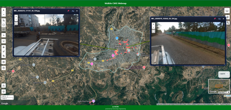
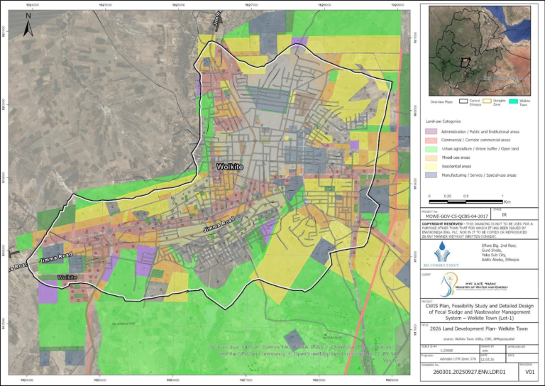
Citywide Inclusive Sanitation (CWIS) – Feasibility Study, ESIA & Detailed Design for Wolkite Town (Ethiopia)
Client: Ministry of Water and Energy (MoWE)
Status: Ongoing
Key Project Activities
🗺️ Spatial Data Development & Integration
Collection, validation, and integration of multi-source spatial datasets (sanitation, drainage, environmental, and infrastructure) to support evidence-based Citywide Inclusive Sanitation (CWIS) planning.
🌍 Terrain & Hydrological Analysis
Advanced GIS analysis including DEM processing, slope classification, watershed delineation, and drainage modeling to guide wastewater flow, flood risk assessment, and infrastructure siting.
🗄️ Geodatabase Design & Management
Development of a structured geospatial database integrating survey data (Kobo/ODK), satellite imagery, and infrastructure layers for long-term planning and decision-making.
📊 Sanitation Feasibility & Spatial Analysis
Assessment of fecal sludge and wastewater management systems based on population density, land use, accessibility, and environmental constraints.
📍 Infrastructure Siting & Suitability Analysis
Identification of optimal locations for fecal sludge treatment plants (FSTPs) and sanitation infrastructure using multi-criteria GIS analysis.
🧭 Baseline Mapping & Spatial Diagnostics
Production of key thematic maps including elevation, drainage networks, land use, population distribution, environmental sensitivity, and sanitation coverage.
♻️ Sanitation Service Chain Mapping
GIS-based assessment of sanitation services across containment, emptying, transport, treatment, and disposal to support targeted interventions.
🌱 Environmental & Social Impact Support (ESIA)
Spatial identification of environmentally sensitive areas and development of impact maps to support environmental and social assessments.
🏗️ Infrastructure Planning & Design Support
Preparation of phased infrastructure layouts and GIS deliverables (maps, shapefiles, and map books) for design and tender documentation.
📁 Data Management & Quality Assurance
Implementation of standardised data management systems, including naming conventions, folder structures, metadata, and version control for multidisciplinary coordination.
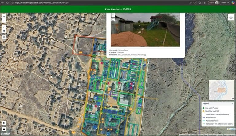
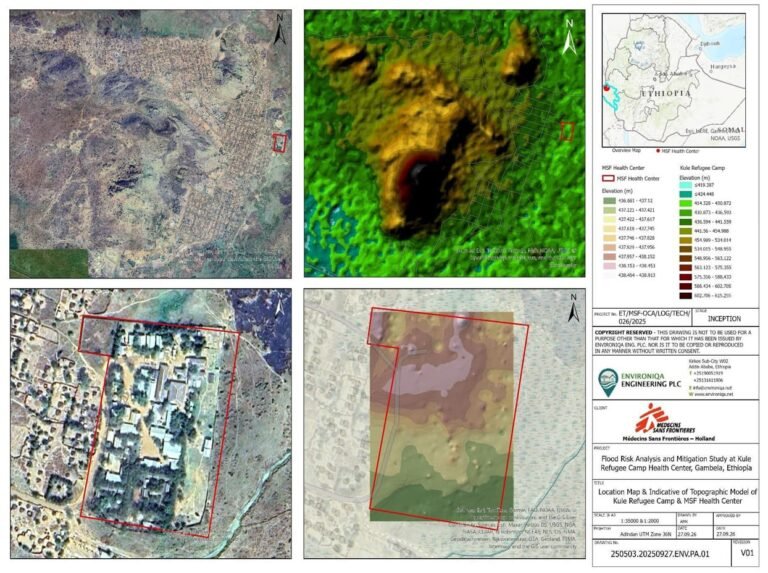
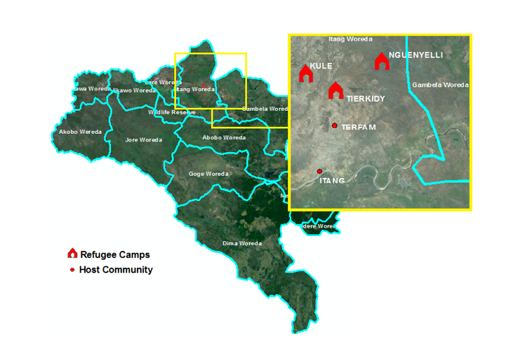
Flood Risk Analysis & Mitigation Measures — Kule Refugee Camp Health Center
Main Consultant: Environiqa Engineering PLC
Status: Ongoing
Key Project Activities
📋 Project Planning & Methodology Development
Defined the overall technical approach, work plan, and delivery framework; established reporting structures and timelines to ensure coordinated execution across multidisciplinary teams.
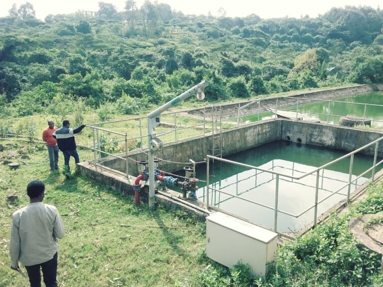
🌍 Data Collection & Site Assessment
Conducted comprehensive data collection and field investigations, including review of topographic and hydrological datasets, historical flood records, and climate patterns; carried out site inspections and stakeholder consultations to identify flood-prone zones, critical infrastructure, and vulnerable assets.
🌊 Hydrologic, Hydraulic & GIS Analysis
Performed and supervised hydrologic and hydraulic analyses supported by GIS; developed model inputs, analyzed runoff behavior, drainage pathways, and bottlenecks; assessed soil saturation and infiltration characteristics; generated spatial flood hazard and risk maps for planning and decision-making.
🛠️ Design Options & Mitigation Strategies
Developed and evaluated flood mitigation measures, including structural solutions (drainage upgrades, retention/detention systems, channel improvements, site elevation) and non-structural measures (early warning systems, operational protocols, and community preparedness strategies), supported by comparative cost and feasibility analysis.
📊 Deliverables & Implementation Planning
Prepared key outputs including inception reports, GIS-based flood risk maps, and a comprehensive final report outlining prioritized interventions, preliminary cost estimates, and a phased implementation roadmap.
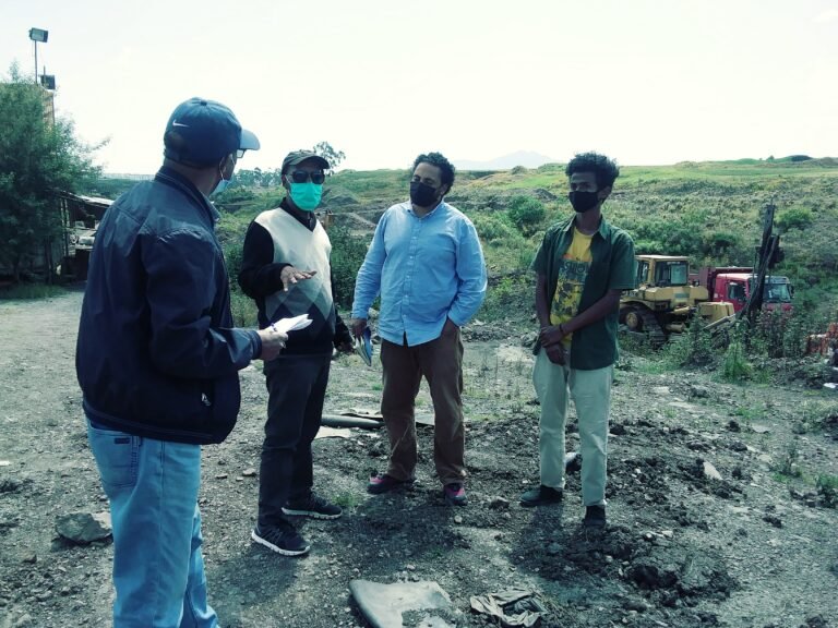
🤝 Stakeholder Engagement & Capacity Building
Engaged with institutional stakeholders, facility managers, and community representatives to validate findings and ensure context-appropriate solutions; aligned recommendations with master planning and environmental standards; supported knowledge transfer on GIS-based flood risk assessment and management.
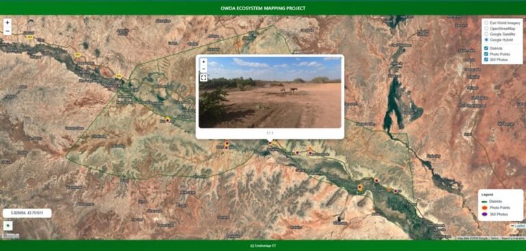
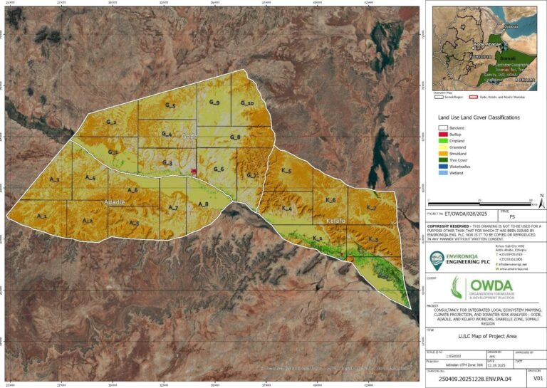
Integrated Ecosystem Mapping, Climate Projection & Disaster Risk Analysis — Shabelle Zone
Client: OWDA (Organization for Welfare and Development in Action) Partner Arche-Nova
Consultant: Environiqa Engineering Plc
Status: Completed
Key Project Activities
🌿 Ecosystem Mapping & Environmental Baseline Development
Geospatial analysis and integration of multi-source datasets, including Sentinel imagery, climate datasets, and field-collected information, to produce high-resolution land use/land cover maps, ecosystem classifications, and environmental baseline data for planning and assessment.
🗄️ Geodatabase Design & Spatial Data Management
Design and management of a structured geospatial database for ecosystem mapping, climate analysis, and disaster risk assessment outputs, ensuring consistency, traceability, quality control, and efficient use of project data.
📍 Field Data Collection & Ground Validation
Support to field data collection and validation workflows using QField, GPS, and transect-based methods, including ground-truthing of land cover classes, vegetation conditions, water resources, and environmental degradation hotspots.
🌦️ Climate Data Processing & Risk Analysis
Processing and preparation of model-ready datasets for climate and disaster risk analysis, including rainfall variability, temperature trends, drought indicators, and flood-prone area identification using gridded climate tools and downscaled projections.
⚠️ Hazard, Vulnerability & Risk Mapping
Development of integrated hazard and risk maps by combining climate data, ecosystem conditions, and community-derived vulnerability and exposure information to support resilience planning and evidence-based decision-making.
🧭 Participatory Mapping & Community Knowledge Integration
Integration of community knowledge from PRA outputs, focus group discussions, and key informant interviews into GIS-based ecosystem and risk assessments, strengthening the relevance and inclusiveness of project findings.
🗺️ Cartographic Outputs & Decision Support
Production of high-quality cartographic outputs, including ecosystem maps, climate trend visualizations, and disaster risk maps, to support technical reporting, planning processes, and stakeholder engagement.
📁 Data Governance & Quality Assurance
Implementation of data governance standards, including naming conventions, metadata documentation, version control, and structured data storage, to ensure reliable, organised, and deliverable-ready project datasets.
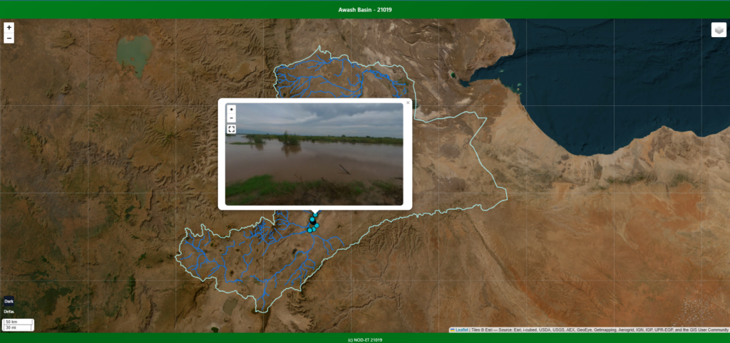
Feasibility Study, Detailed Design & Tender Documentation for Awash River Flood Risk Reduction and Associated Infrastructure
Consultant:Nicholas O’Dwyer Ltd
Status: Ongoing
Project: River Awash Flood Resilience Project
Key Project Activities
🧾 Data Audit & Consolidation
Collection, review, and consolidation of hydrologic, hydraulic, topographic, survey, and infrastructure datasets to establish a reliable project-wide data foundation for flood analysis and design.
🛰️ Terrain Mapping & Survey Integration
Processing of terrain and survey data, including DEMs, orthophotos, photogrammetry, and related spatial products, to support floodplain assessment and dyke alignment optimisation.
🗄️ Geodatabase Design & Data Management
Development and maintenance of a structured geodatabase with metadata, version control, lineage tracking, and quality assurance to support consistent and auditable project workflows.
📈 Hydrologic & Hydraulic Model Input Preparation
Preparation of model-ready datasets for flood modelling, including catchment delineation, surface roughness, boundary conditions, rainfall parameters, and scenario libraries for hydrologic and hydraulic analysis.
🌊 Flood Hazard & Risk Mapping
Production of baseline and with-project flood hazard maps covering fluvial and pluvial flood mechanisms, supporting risk assessment, design evaluation, and decision-making.
🛠️ Feasibility & Optioneering Support
Support for flood risk analysis, option development, and comparative assessment of mitigation measures to inform feasibility studies and project planning.
📐 Detailed Design Support
Preparation of spatial and analytical inputs required for detailed design, including design basemaps, terrain products, alignment support data, and coordinated GIS outputs.
📝 Inception Reporting & GIS Coordination
Data collation, organization, and GIS coordination for inception-stage deliverables, together with establishment of structured data-sharing systems for the wider project team
🤝 Multidisciplinary Coordination
Close coordination with environmental, social, geotechnical, and constructability specialists to ensure integrated and practical flood resilience solutions.
🗺️ Cartography & Decision-Support Outputs
Preparation of high-quality flood maps, map books, and visual outputs with clear symbology and layout standards for technical review and stakeholder decision-making.
🎓 Capacity Building & Systems Support
Support for GIS system setup, team data workflows, and capacity building to strengthen project delivery and long-term data use.
📁 Data Governance & Quality Assurance
Implementation of naming conventions, folder structures, access controls, version control, and data management procedures to ensure secure, organised, and deliverable-ready project information.
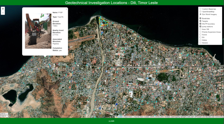
Consultancy Services for the Preparation of Designs, Tender Documents, Environmental and Social Impact Assessment (ESIA) and Resettlement Action Plan (RAP) for the Water, Sanitation and Drainage Project, Dili, Timor-Leste
Main Consultant: Nicholas O’Dwyer Ltd
Status: Completed
Key Project Activities:
📍 Leading large-scale LiDAR, photogrammetric, GNSS, and 360° infrastructure surveys for topographic, hydrological, asset, and sanitation data collection.
🗺️ Conducting geospatial and photogrammetric analysis to produce digital elevation models, surface models, and orthophotos
🛠️ Coordinating geotechnical investigations, including boreholes and trial pits, and designing digital forms for topographic, socio-economic, and sanitation data collection
🌐 Developing and maintaining a comprehensive geodatabase and creating interactive web maps to support wastewater infrastructure planning and decision-making
📐 Assisting sanitation engineering and sewer design through ground-truthing, verification of sewer alignments and outfalls, preliminary sewer layout development, design tasks, profile and level checks, quantity take-off support, and drawing updates based on field findings.
🤝 Managing multidisciplinary teams, delivering technical training, and collaborating with clients, stakeholders, and project teams throughout project implementation
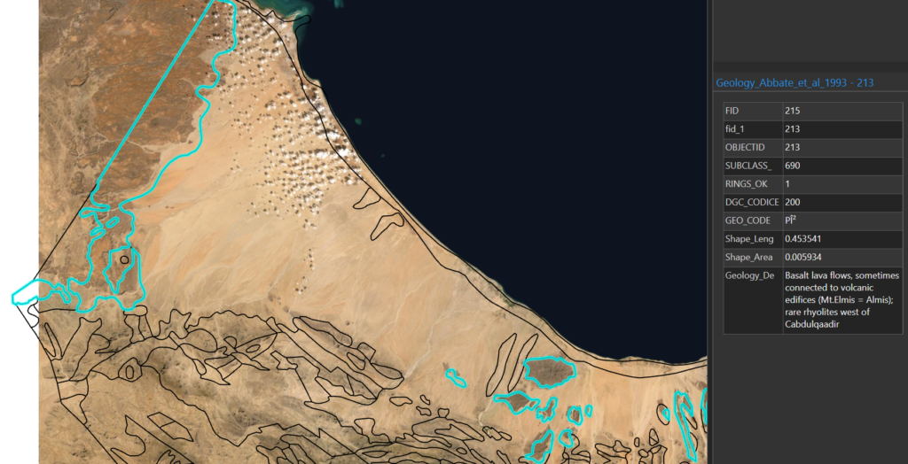
Hydrogeological Groundwater Mapping Project (2022, Hargeisa, Somaliland)
Client: UNICEF
Main Consultant: MS Consultancy and Acacia Waters
Subconsultant: Environiqa Engineering Plc
Status: Completed
Key Project Activities:
🛰️ Collecting, compiling, and organising groundwater-related spatial and attribute data, including topographic, geological, hydrogeological, borehole, and water quality datasets.
🗂️ Developing and maintaining a structured geodatabase to integrate groundwater information for mapping, analysis, and reporting.
🧭 Preparing hydrogeological base maps and thematic layers to support groundwater resource assessment and spatial interpretation.
📊 Conducting spatial and geostatistical analysis to evaluate the distribution, variability, and correlation of key groundwater parameters.
💧 Generating groundwater potential maps to identify promising zones for groundwater development and support evidence-based planning.
📍 Analysing borehole records, aquifer characteristics, and field investigation results to improve groundwater targeting and drilling success.
🌍 Applying GIS, remote sensing, and map-based analysis to assess groundwater occurrence, recharge potential, and spatial trends across the project area.
📈 Producing map outputs, technical visuals, and decision-support materials for groundwater planning, resource management, and stakeholder engagement.
🤝 Collaborating with clients, stakeholders, and multidisciplinary teams to ensure coordinated, efficient, and high-quality project delivery.
Development of an Integrated Town Wide Sanitation Plan, Feasibility Study and Detail Design of WasteWater Management System for Jigjiga and Degahbur
Client: Somali Regional State Water Bureau
Main Consultant: Nicholas O’Dwyer Ltd
Status: Completed
Key Project Activities:
Provision of GIS and Sanitation Engineering services, including:
🗂️ Developing and maintaining a geodatabase for sanitation asset management, planning, and decision support.
🗺️ Conducting geospatial, photogrammetric, and spatial analysis to support sanitation planning, infrastructure mapping, and service area assessment.
📍 Leading and coordinating GNSS surveys, site investigations, and geotechnical assessments to inform planning and design decisions.
📐 Supporting sanitation master planning through the preparation of base maps, thematic maps, catchment maps, and priority intervention areas.
🚽 Designing sanitation systems, including sanitary sewer networks, toilet facilities, and faecal sludge treatment plants.
🌍 Assessing existing sanitation conditions, settlement patterns, topography, and service gaps to guide appropriate sanitation solutions.
🔄 Supporting the planning of both sewered and on-site sanitation systems, including wastewater and faecal sludge management components.
📊 Preparing technical layouts, map outputs, and planning visuals to support design development, stakeholder review, and project reporting.
👷 Managing and coordinating multidisciplinary teams of engineers, surveyors, and data collectors to ensure efficient project implementation.
🤝 Collaborating with clients, stakeholders, and multidisciplinary teams to ensure coordinated delivery and high-quality project outcomes.
Eastern Wastewater Catchment Feasibility Study (2020 – ongoing, Addis Ababa,Ethiopia). Client: Addis Ababa Water & Sewerage Authority
Main Consultant: MS
Consultancy and Nicholas O’Dwyer Ltd
Status: Completed
Key Project Activities:
GIS and Sanitation Engineering services, including
🛰️Coordinating and managing geotechnical and soil investigation studies
📍Planning and managing GNSS surveys and household surveys
🗂️Developing a geodatabase and conducting geospatial and photogrammetric analysis
📈 Performing hydraulic design for sewer networks
📊 Preparing maps, drawings, and design reports
🤝Providing training sessions for data collectors and stakeholders to enhance project implementation

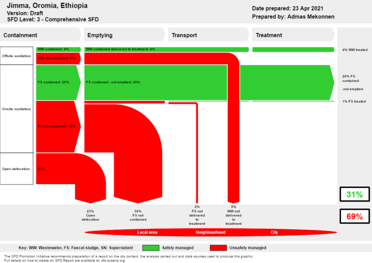
Citywide Sanitation Plan & Wastewater System Development (Jimma & Nekemte) (2020,Oromia Region, Ethiopia) | Client: Oromia Water, Mineral and Energy Bureau
Main Consultant: MS Consultancy Plc
Subconsultant: Environiqa Engineering Plc
Status: Completed
Key Project Activities: GIS and Sanitation Engineering services, including,
📈 Leading the acquisition and analysis of spatial and socio-economic data for
sanitation planning, and establishing comprehensive geodatabases for spatial and geostatistical analysis
👷 Recruiting and training enumerators, and supervising household and topographic surveys using digital data collection platforms
🌍 Applying Citywide Inclusive Sanitation (CWIS) tools to assess sanitation conditions and identify system improvement opportunities
📐 Designing sewer lines and developing hydraulic models to ensure efficient
wastewater conveyance and treatment
Integrated Citywide Sanitation Plan for Harar City (2019 – 2020, Harar, Ethiopia)
Main Consultant: MS Consultancy Plc
Subconsultant: Environiqa Engineering Plc
Status: Completed
Key Project Activities: GIS and Sanitation Engineering services, including,
📈 Leading the acquisition and analysis of spatial and socio-economic data for
sanitation planning, and establishing comprehensive geodatabases for spatial and geostatistical analysis
👷 Recruiting and training enumerators, and supervising household and topographic surveys using digital data collection platforms
🌍 Applying Citywide Inclusive Sanitation (CWIS) tools to assess sanitation conditions and identify system improvement opportunities
📐 Designing sewer lines and developing hydraulic models to ensure efficient
wastewater conveyance and treatment
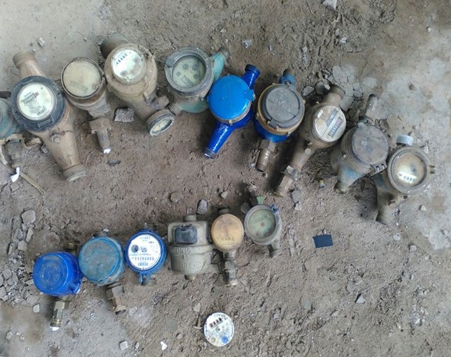
Non-Revenue Water Reduction & Pressure Management (Jimma) (2018,Jimma, Ethiopia)
Main Consultant: MS Consultancy
Subconsultant: Environiqa Engineering Plc;
Status: Completed
Key Project Activities: GIS and Water Supply Engineering services, including,
– Conducting field assessments of existing infrastructure
– Developing a geodatabase for asset management
– Developing hydraulic models for system analysis and NRW assessment
– Proposing mitigation measures for non-revenue water
– Preparing maps, drawings, and reports
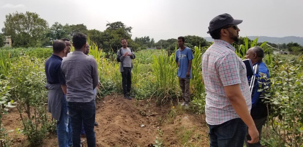
Design of Wastewater & Solid Waste Facilities for Refugee Camps (2018, Gambella,Ethiopia)
Main Consultant: MS Consultancy
Subconsultant: Environiqa Engineering Plc;
Status: Completed
Key Project Activities: GIS and Water Supply Engineering services, including,
– Designing survey questionnaires using QField and KoboToolbox and coordinating fieldwork for waste characterization and infrastructure assessments
– Developing geodatabases for asset management and conducting spatial and
geostatistical analyses, including site selection assessments
– Assessing existing waste disposal infrastructure and designing optimized solid
waste and toilet facilities
– Preparing maps, drawings, and reports, and collaborating with multidisciplinary
teams to ensure holistic project implementation
Click On the Map to Check Out Our Projects Interactive Webmaps
Clients We Worked With


Have a Project in mind?
Let’s talk about what we can build together.
